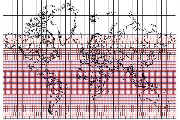
Another complexity that might somehow be added to computerized role-playing games or wargames, or global strategy games of one sort or another is illustrated by the diagram below:
If one is going to divide the world up into a lot of little squares, and these squares all represent the same area, then one has to make some little adjustments here and there, given that the world *is* round, after all.
This map illustrates *one* way of doing this, the one I believe is the simplest. But others may want to take the lead from what surveyors and soldiers have done in the real world, and go with a Transverse Mercator grid system instead.
But even if one admits that the issues created in going from one standard meridian to another for a Universal Transverse Mercator grid system are too complicated, how would the issues created by even the relatively simple grid I illustrate above be dealt with?
As the grid is built on a map in the Mercator projection, built to a limited scale, the adjustment of the small squares on the map is fairly coarse. And the illustration does have a simple square grid underlying it, the grid of single pixels.
So, while in a simple game with a crude display, where the player and creatures move in steps from the center of one square to the center of another square, in a game with fancier graphics that attempts to conceal the grid from players, movement coordinates could be in terms of the underlying purely rectangular grid, with the adjusted grid determining the size of terrain features and the scale at which the map is displayed. So, when you cross to a more poleward band, the display shrinks, but you are not jerked to the left or right. It could even be made to shrink gradually.
In the map above, the size of grid squares increases abruptly from three pixels to four, then to five, and so on, up to eleven. Going from three pixels to four, one has a missing square for every four small squares.
One thing that might be usable in favor of avoiding problems is the fact that the world is a large place. The diagram above shows a world that is girdled at the Equator by 144 grid squares.
Let us say that a grid square in a dungeon represents an area of 10 feet by 10 feet. Dungeons being local areas, they would not be affected by this, and would use a normal square grid. Some games will use the same scale for terrain, and others will use a larger scale, perhaps slightly larger, such as 60 by 60 feet, or so much larger that encounters while on terrain switch to an encounter screen, a grid square on terrain being equivalent to a full screen of dungeon grid squares; in that case, let us take 1200 by 1200 feet as a possible value.
The radius of the Earth is 7,927 miles. Let us approximate that by 8,000 miles. Let us approximate pi by 3, giving the Earth a circumference of 24,000 miles. A mile is 5,280 feet; let us approximate that by 5,000. This gives us an Earth with a circumference of 120,000,000 feet.
Even with the coarsest grid size given above, where a terrain grid is equal to a 20 by 20 set of combat grid squares, the world has 100,000 grid squares girdling it at the Equator. This would allow a large number of latitude bands, making the missing grid squares at each boundary infrequent enough that one could imagine that a game program might be able to shift their locations slightly so as to dump them in impassable terrain features.
Perhaps the most consistent approach would simply be to define things directly in terms of the globe. One could have little round tiles with buildings on them or segments of roads, rivers, or mountain chains, connected by tiles with two convex sides to join two round tiles. The space between tiles would contain generic grassland, desert or sea terrain. Forests could be built from a layer of mini-tiles the size of trees if necessary.
Thus, the fact that no small tile (as opposed to, for example, 12 large tiles that could cover the globe following the faces of a dodecahedron) can tesselate the globe properly is dealt with by not requiring a tesselation, only tree-like networks of linked features.
Of course, one could choose the size of the round tiles and the tiles that join them so that one could have one particular type of globe-girdling construct; for example, connected tiles corresponding to the edges of a truncated icosahedron; that is, the pattern of a soccer ball.
It may be noted, though, that this sort of thing is really only a concern if at least one of the following two conditions is true: one is using a globe with randomly-generated continents, and one wants North to always be at the top of the screen.
If neither of these conditions are true, one can always use an interrupted map projection of some type, and apply a plain square or hexagonal grid to the map. As examples of interrupted map projections that would be "good enough", I provide as one example the following conformal projection:
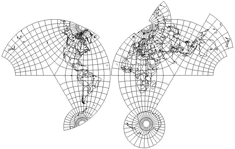
this, representing the Eastern and Western hemispheres by a transverse Lambert Conformal Conic with one standard parallel at approximately 41.8103149 degrees, in addition to representing the world nicely, by mapping each hemisphere to a cone that unfolds to be exactly 2/3rds of a circle, happens to be well-suited to the use of a hexagonal grid!